Island 25
Mississippi County, Arkansas – near Blytheville, Arkansas
+/- 1,004.51 Acres – reported by the current owner
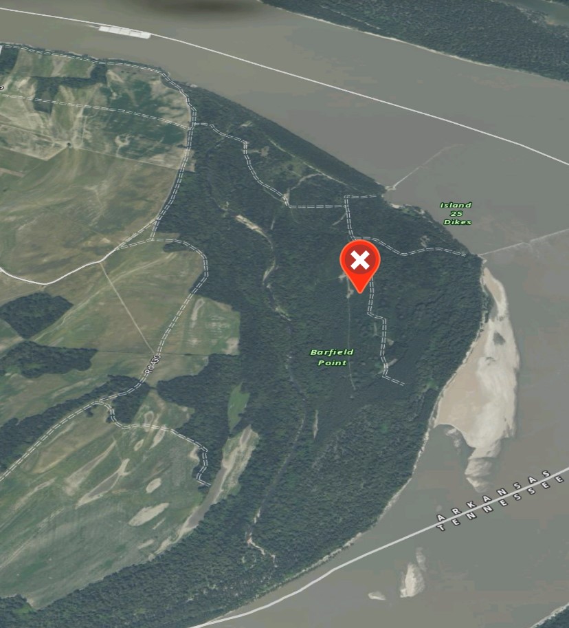
The Island 25 property contains 1004.51 acres, more or less, and is located in the northeastern part of Mississippi County, Arkansas. The land consist of some WRP acreage in the remainder in wetlands with the majority of the timber being cottonwoods. There is a small amount of Cottonwood plantation on the property. The property is on the inside bend of the Mississippi river on the unprotected side of the levee. The property has been used as recreational hunting tract with some timber production for a number of years.
Property location:
The track is located 12 miles south east of Blytheville Arkansas and 17 miles northeast of Osceola, Arkansas. The property runs along the west side of the Mississippi river inside the mainline Levee system. The track is situated in the north eastern portion of Mississippi County. The property is in sections 8, 16, 17, 20 and 21, Township 14 North, Range 13 East.
The property is currently use for recreation with and has significant timber production opportunities. They are presently no other uses. Island 25 property contains approximately 1004.51 acres more or less in one irregular shaped block, which is bordered on the east side by the Mississippi river, on the west side by an old river shoot, and agricultural farmland located inside the mainland river Levee. The size of the subject is not considered to be uncommon or unusual for the region. The property is currently use for recreation uses with a total area of 1004.51 acres there are 471.1 acres in rolled in wetlands reserve program. The balance of the acreage consist of Woodlands, lakes, river and accretion land. The shape of the subject property is in a regular blocked. The topography of the track is undulating to level land, with some portions at lower our elevations a long drainage is, old River runs, and the river as is typical of the immediate area. The highest portion of the trackers on the western side and is at 255 feet above sea level. The lowest elevation, 240 feet, is found on the eastern portion. The irregularity of the track is not detrimental.
Available utilities:
Presently utilities to the property are none. There are no utilities available near the property.
Access to site:
The property is accessed via a farm road across the adjoining landowner from County Road 430, along with a network of interior roads that run through the subject property. There is no public access to the property but the property is being purchased with a deeded easement from the adjoining land owner. See attached location map and photographs. Access to various areas of the property is considered adequate.
Improvements on the property
The property has a network of roads along with deer stands and food plots. Additionally there is an iron Bridge installed across the old river shoot. The improvements noted on the subject property have contributed value to the property and is considered in the overall land value.
Minerals
The ownership of mineral rights for the subject property has not been determined but it is assumed that all mineral rights are owned by the current owners.
Timber
The tract has a significant stand of natural regenerating hardwoods and softwoods. The property’s highest and best use would be recreational in nature. Therefore the use of the property strictly for timber production with diminished recreational value. An estimate of timber value was not obtained however most of the comparable sales included some timber and the indication of value will be inclusive of the recreational benefits provided by the timber. The complete harvest would be detrimental to the recreational quality and would diminish the properties value. Furthermore there are 471.1 acres restricted by WRP easement in these acres could not be harvested. The majority of the WRP acreage does not have any significant timber.
Recreation considerations:
The subject property is in close proximity to many other recreational tracks that have been utilized for a pond game and waterfowl hunting for a number of years. Just to the east across the Mississippi river is the Chickasaw National Wildlife Refuge, which is a public recreational hunting track. Realfoot National Wildlife Refuge is situated approximately 40 miles north east of the subject property. Furthermore for Pillow State Wildlife Management area is just to the south west of the subject property in Big Lake State wildlife management area is roughly 20 miles to the west. Overall the subject property has good recreational characteristics. The property would be considered to have good Whitetail deer, turkey, and small game hunting. The property is located in a region known for duck hunting it would be considered to have good potential for that duck deer and turkey hunting
For more information and pricing, please call Ben Wellons at 501.482.LAND (5263) or [email protected]
| Price: | $1,500,000 |
| Address: | +/- 1004.51 Acres on Mississippi River |
| City: | Blytheville |
| County: | Mississippi County |
| State: | Arkansas |
| Zip Code: | 72315 |
| Acres: | 1004.51 |